Home
Weather London
WeatherRadar
RainfallRadar
TemperatureRadar
WindRadar
LightningRadar
Weather News
Editor's Pick
Discover the app
Weather widget
Contact us
Apps
Career
    Home / Editor's Pick /

    A heatwave is on the way in Europe – is El Niño to blame?

07:13
16 June 2026

Is El Niño to blame?
A heatwave is on the way in Europe

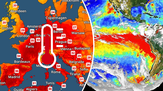
Split image showing a Europe temperature map with widespread red heatwave conditions and temperatures above 30 C on the left, and an El Niño ocean temperature anomaly map of the Pacific Ocean on the right with a broad band of unusually warm water along the equator.
Will El Niño impact temperatures here? - © picture alliance

A heatwave is building once again across Europe. At the same time, the El Niño weather phenonmenon has formed over the eastern Pacific. Is there a link?

Despite some reports, the answer to this question is a resounding no. Although the onset of the El Niño phenomenon has now been officially confirmed, its effects are essentially limited to regions in and around the Pacific Ocean.

Did you know?

The El Niño weather phenomenon recurs every two to seven years with varying intensities. Initial calculations suggest that the El Niño event currently getting underway is likely to be particularly strong. 

This is particularly noticeable in South America and South-East Asia. As a result, increased flooding, heatwaves and droughts are expected there in the coming months. But in California and parts of Mexico, too, the weather could literally go haywire due to El Niño.

In contrast, the heatwave currently sweeping across south-western Europe has nothing to do with El Niño. Rather, a summer "heat dome" has formed over Spain, which is now slowly spreading towards Central Europe.

In fact, the heat in Spain and France is likely to intensify even further as the weekend approaches: maximum temperatures of around 40 °C, or even higher, are expected there.

Learn more about El Niño and the El Niño Southern Oscillation.

Weather & Radar editorial team
More on the topic
Drought for North Wales and Upper Severn. 2% of average rainfall. . . Thursday, 23 July 2026
Split image showing a July rainfall anomaly map of Europe on the left with below-average rainfall across the UK, Ireland, and much of western and central Europe, and an active moorland wildfire on the right producing flames and thick smoke near homes.
Thursday, 23 July 2026

2% of average rainfall

Drought for North Wales and Upper Severn
New heatwave in southern Europe. Up to 45 degrees in Spain. . . Tuesday, 21 July 2026
Split temperature map showing extreme heat across Spain on the left and Greece on the right, with temperatures reaching 44°C near Murcia, around 40°C in parts of Greece, and a large thermometer icon highlighting dangerous heat.
Tuesday, 21 July 2026

Up to 45 degrees in Spain

New heatwave in southern Europe
Drought across large parts of Europe. High fire risk. . . Monday, 20 July 2026
Split image showing a Europe rainfall anomaly map on the left with widespread dry conditions across much of the continent, and a cracked, parched field on the right alongside a wildfire warning symbol highlighting elevated fire risk.
Monday, 20 July 2026

High fire risk

Drought across large parts of Europe
All weather news
This might also interest you
Super Typhoon Bavi threatens Taiwan. Up to 1,000 mm of rain. . . Wednesday, 8 July 2026
The image shows an intense tropical cyclone over the western Pacific, east of Taiwan and the Philippines. The centre of the system is depicted as a light purple and white vortex with a clearly visible eye, surrounded by a ring of red and orange areas indicating the strongest wind speeds. A white arrow marks the typhoon’s predicted track towards the north-west, in the direction of Taiwan. To the west of the storm lie the Philippines, with the cities of Manila and Cebu; to the north of these lies Taiwan, with Taipei. Further west, the Chinese coast, including Hong Kong, and parts of Vietnam can be seen. The coloured wind map shows predominantly green areas outside the storm’s core, indicating significantly weaker winds. White streamlines illustrate the typhoon’s anti-clockwise circulation in the Northern Hemisphere. The highest wind speeds are concentrated around the eye of the cyclone.
Wednesday, 8 July 2026

Up to 1,000 mm of rain

Super Typhoon Bavi threatens Taiwan
Turbulent weather in the Canary Islands. Storm and rain. . . Friday, 12 December 2025
Weather graphic showing rain and wind fields over the Canary Islands and a central warning symbol.
Friday, 12 December 2025

Storm and rain

Turbulent weather in the Canary Islands
New records for England and Wales. Broken again tomorrow?. . . Thursday, 25 June 2026
Temperature map of southwest Britain on 25.06 showing extreme heat across southern Wales and southwest England, with Bute Park in Cardiff highlighted at 34.2°C and Yeovilton at 36.4°C amid widespread deep red heat zones.
Thursday, 25 June 2026

Broken again tomorrow?

New records for England and Wales
All articles
Weather & Radar

Weather & Radar is also available on

Google Play StoreApp Store

Company

Contact us Privacy Policy Legal info Accessibility statement

Services

Uploader

Socials

facebooktwittertikToklinkList